7
Highway pads
Lots 1, 2, 3, 4, 14, 16, 17 · direct US‑290 frontage
- Acres per lot
- 0.81–1.56
- US‑290 frontage per lot
- 117′–259′
 Elgin Commons
For sale · Pad sites · Hotel site · Phase 2 tracts
Sixty platted acres on US‑290, 0.6 miles from Walmart and 0.9 miles from H‑E‑B.
The site today, looking east toward Elgin — CIP drone photography
Not another corner. A whole new block of Elgin retail.
Elgin Commons is a ±59.99-acre, 18-lot platted commercial development with 1,577 feet of frontage on US Highway 290 — the east–west spine that carries 35,780 vehicles a day between Austin and Elgin. It sits 0.6 miles west of the Walmart Supercenter and 0.9 miles west of H‑E‑B, the two stores that anchor the city’s daily shopping.
The plat delivers highway and interior pad sites from 0.8 to 3.5 acres, a 4.2-acre hotel pad, and a 31-acre second phase that could support an anchored center, destination entertainment or additional retail — served by three internal public streets and a proposed future traffic signal on US‑290. Phase 1 pads are offered for sale, individually or in combination; Phase 2 is positioned for a single developer.
Pads for sale now. Phase 2 for one developer.
Lots 1, 2, 3, 4, 14, 16, 17 · direct US‑290 frontage
Lots 6, 7, 8, 9, 13 · Clydesdale Dr, Indian Paintbrush Trl & Lee Dildy Blvd
Lot 10 · Lee Dildy Blvd extension
Lots 11 & 12 · potential anchored-center, entertainment or retail development; no use committed
Twelve pads and the hotel site, sold lot by lot
Adjacent pads can be combined for larger users
Case by case, at ownership’s discretion
Lots 11 & 12 offered together · pricing: contact broker
54.08 net acres across 18 platted lots. Select a lot on the plan or in the schedule.
Lot lines from the Final Plat, Rhode Tract Subdivision (BGE, Inc.), fitted to Bastrop CAD parcel corners within about 5 ft. Approximate and for illustration only; not a survey.
| Lot | Location | Acres | US‑290 ft | Status |
|---|---|---|---|---|
| Highway pads · direct US‑290 frontage | ||||
| Lot 1 | Clydesdale Dr corner | 1.563 | 145.86′ | For sale |
| Lot 2 | Clydesdale Dr corner | 0.808 | 190.08′ | For sale |
| Lot 3 | Mid-block | 0.808 | 190.08′ | For sale |
| Lot 4 | Mid-block | 0.836 | 117.37′ | For sale |
| Lot 14 | Indian Paintbrush Trl corner | 0.876 | 140.01′ | For sale |
| Lot 16 | Mid-block | 1.020 | 159.02′ | For sale |
| Lot 17 | East end | 1.245 | 258.74′ | For sale |
| Lot 15 | Medical use | 1.501 | 236.02′ | Under contract |
| Interior pads | ||||
| Lot 6 | Clydesdale Dr | 0.866 | — | For sale |
| Lot 7 | Interior | 1.135 | — | For sale |
| Lot 8 | Lee Dildy Blvd | 3.450 | — | For sale |
| Lot 9 | Lee Dildy Blvd | 1.208 | — | For sale |
| Lot 13 | Indian Paintbrush Trl | 0.909 | — | For sale |
| Lot 18 | Breakfast use | 0.516 | — | Under contract |
| Hotel pad | ||||
| Lot 10 | Lee Dildy Blvd extension | 4.198 | — | For sale |
| Phase 2 tracts · developer sale | ||||
| Lot 11 | Development tract | 17.822 | — | Developer sale |
| Lot 12 | Development tract | 13.532 | — | Developer sale |
| Not offered | ||||
| Lot 5 | Detention | 1.790 | — | Detention |
Acreage and frontage per Final Plat, Rhode Tract Subdivision (BGE, Inc.) and Bastrop CAD records; total frontage includes the 80.00′ (Clydesdale Dr) and 60.01′ (Indian Paintbrush Trl) street entries. Locations summarized from the plat; buyer to verify all dimensions, easements and availability.
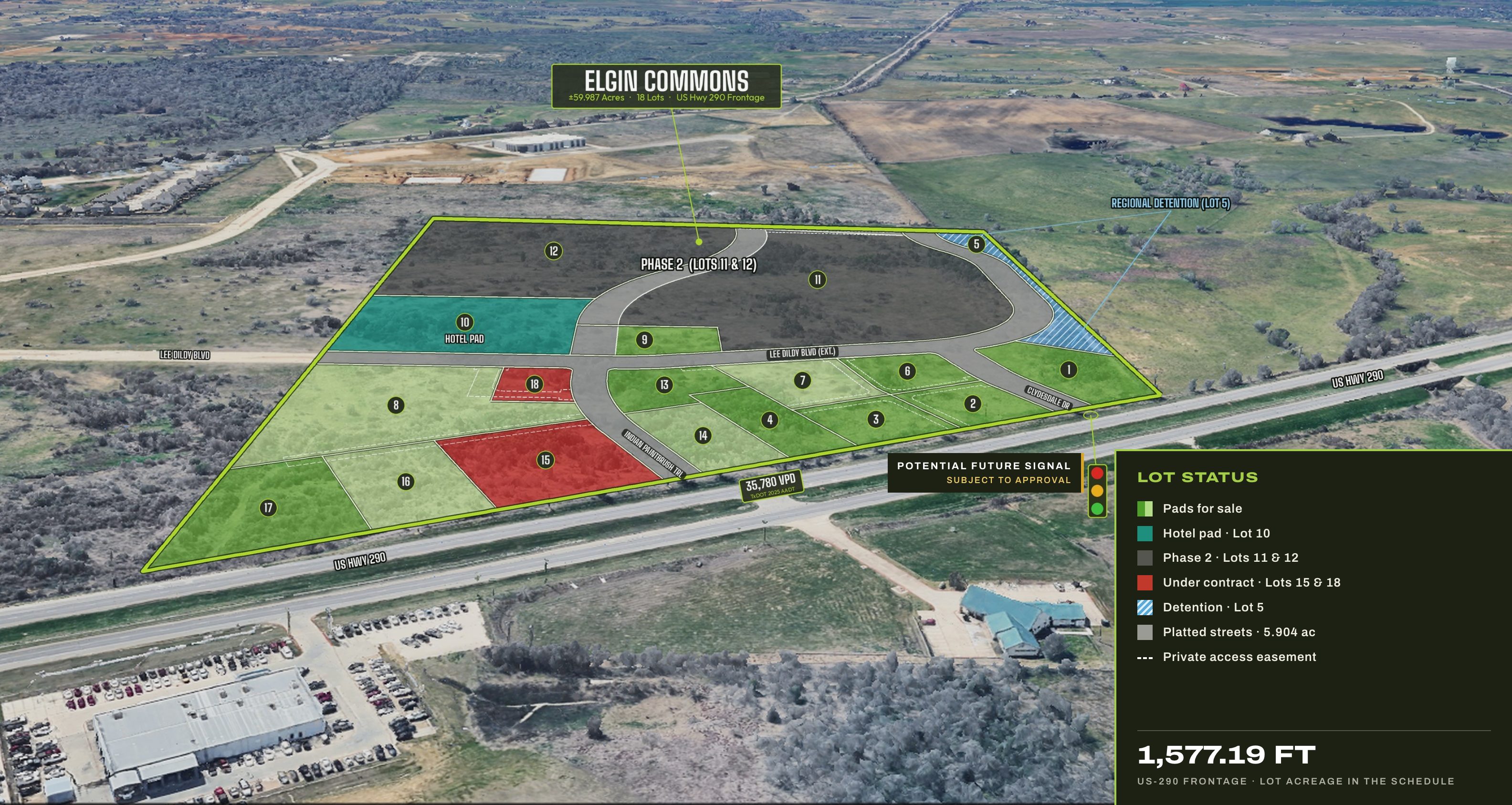
Pads up front, a hotel on the boulevard, and room behind for what comes next.
Interim conceptual imagery for illustration only — not a commitment to any design, tenant or use.
Elgin Commons extends the city’s established US‑290 retail node to the west.
Photo: looking west along US‑290 from the Walmart Supercenter toward Elgin Commons — CIP drone photography.
Eight lots address US‑290 directly. The plat adds two public entries from the highway and extends Lee Dildy Boulevard through the middle of the site.
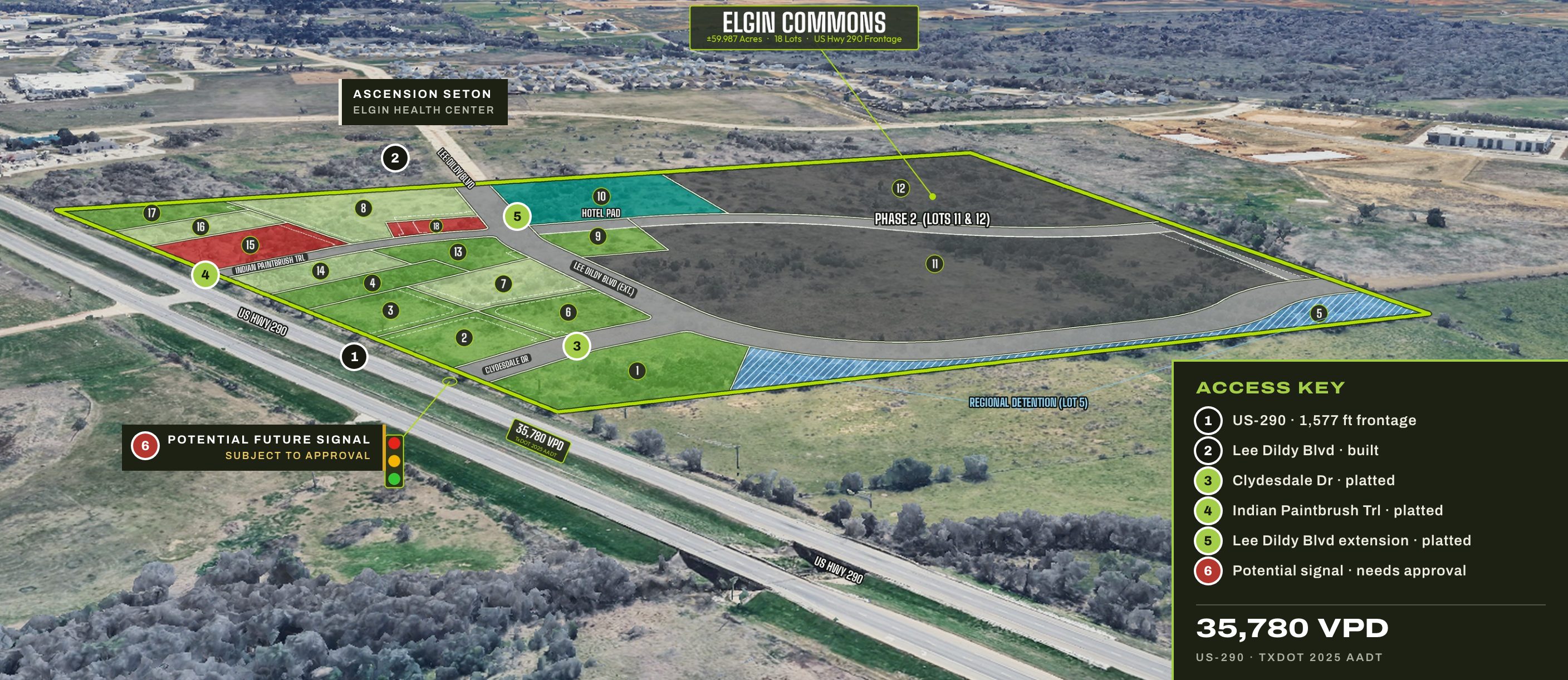
1,577.19 ft of highway frontage; 35,780 vehicles a day per the nearest TxDOT count station, west of the site
Built east of the site, connecting to the Walmart and H‑E‑B retail node
Platted 80′ and 60′ public rights-of-way from US‑290 into the site
Platted through the site; construction projected to begin January 2027
Potential future signal. Approval, funding and schedule are not confirmed
Not shown. Access points and turn movements on US‑290 are subject to TxDOT permitting
An approved agreement, with roads and utilities planned behind it.
Elgin Commons is not a speculative plat waiting on infrastructure. The City of Elgin and the Elgin Economic Development Corporation have approved an economic development agreement for the project, public infrastructure funding was approved with it, and construction of the roads through the site is projected to begin in January 2027.
The City of Elgin is the wastewater provider under the plat, and the approved EDC infrastructure funding includes a wastewater line extension to the project. Detention is platted on Lot 5. Capacities and delivery dates are being confirmed.
City construction of the public roads through Elgin Commons is projected to begin in January 2027, to deliver the platted internal street network. The date is a projection, not a guaranteed delivery schedule.
Elgin City Council unanimously approved the project’s economic development agreement on December 16, 2025. As reported, the Elgin EDC package provides up to $5 million for public infrastructure and up to $4.25 million in sales-tax grant reimbursements.
Planned-development zoning approved by City Council
Economic development agreement — unanimous council vote
Projected start of City road construction
Total project value cited by the City
Incentive terms and project value as reported by the Elgin Courier (Dec. 24, 2025); benefits and obligations are governed by the executed agreements. Road and utility dates are projections. Utility capacities, connection responsibilities and delivery dates to be confirmed lot by lot.
Topography, flood mapping and drainage.
Sources: contours and parcel frame, Bastrop Central Appraisal District map exports of November 12, 2026 (BIS Consulting). Flood hazard, FEMA National Flood Hazard Layer, retrieved November 12, 2026. Boundary and lots, Final Plat, Rhode Tract Subdivision (BGE, Inc.), fitted to the CAD parcel corners within about 5 ft. For information only. This exhibit is not a survey and was not prepared for legal, engineering or surveying purposes; all locations are approximate.
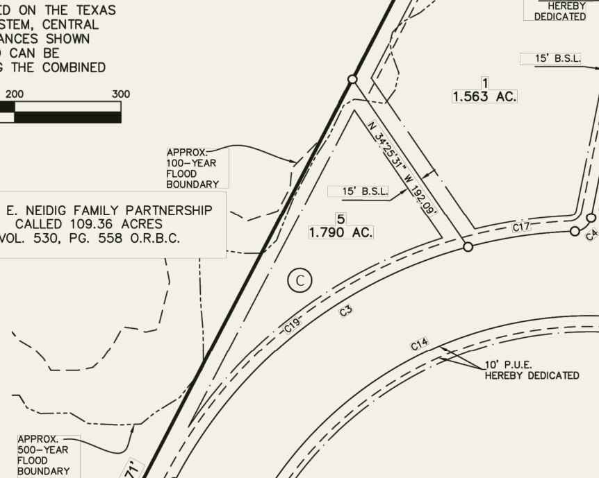
The ground climbs from northwest to southeast. Contours from 510 to 550 ft cross the tract: the US‑290 pads sit at roughly 510–530 ft, and the hotel pad and Phase 2 tracts at roughly 510–550 ft. Grading needs a topographic survey and civil design.
FEMA Zones A and AE follow the creek west of the tract and cross to the north side of US‑290. As plotted here, the mapped hazard stops about 115 ft short of the west line nearest Lots 1 and 5. Plat note 2, however, says a portion of the tract lies in the flood hazard area, and the plat draws approximate 100- and 500-year lines at the west line beside Lot 5. Neither source fixes the boundary lot by lot; that needs a surveyor or engineer.
Lot 5 (1.790 ac) is platted for detention, privately owned and maintained per plat notes 13 and 16. Capacity, construction status and any on-lot requirements are to be confirmed with the project engineer and the City.
Flood boundaries, grades, buildable area, floor elevations and insurance need engineering and regulatory review.
Elgin Commons sits where the three things retailers underwrite already overlap: a trade area of nearly 54,000 people growing 4% a year, family households that own their homes and earn six-figure average incomes, and the highway that carries them to and from Austin every day. The figures below are all measured inside a 15-minute drive of the site.
The 15-minute trade area holds 53,950 residents today, up 38% since the 2020 Census.
53,950Residents · 2025Esri projects 65,627 residents by 2030 — growth of 4.0% a year, several times the national pace.
65,627Residents · 203017,733 households today, adding more than 800 new households every year through 2030.
4.45%Household growth / yrFour of five households own their home, and owner households are the fastest-growing group at 4.7% a year.
81%Owner-occupiedAverage household income tops $109,000; the median is $91,906 and projected to reach $104,897 by 2030.
$109,523Avg household incomeThe Austin–Elgin highway carries 35,780 vehicles a day past 1,577 feet of Elgin Commons frontage.
35,780Vehicles / day · TxDOT 2025Demographics: Esri 2025 / 2030, 15-minute drive time · Traffic: TxDOT 2025 AADT.
The 15-minute trade area added roughly 14,900 residents between the 2020 Census and 2025, and Esri projects another 11,700 by 2030. Two-thirds of its households earn between $60,000 and $200,000.
Population within a 15-minute drive of the site.
| 5 min | 10 min | 15 min | |
|---|---|---|---|
| People and households | |||
| Population, 2025 | 11,338 | 25,152 | 53,950 |
| Population, 2030 | 14,147 | 31,661 | 65,627 |
| Households, 2025 | 3,802 | 8,217 | 17,733 |
| Owner-occupied housing units | 3,005 | 6,693 | 14,400 |
| Median age | 35.3 | 35.2 | 34.8 |
| Income | |||
| Average household income | $102,924 | $104,551 | $109,523 |
| Median household income | $85,690 | $87,690 | $91,906 |
| Annual growth, 2025–2030 | |||
| Population | 4.53% | 4.71% | 4.00% |
| Households | 4.68% | 5.09% | 4.45% |
Drive times from the site. Esri forecasts for 2025 and 2030; U.S. Census 2020.
Three kinds of evidence sit behind that headline, and they carry different weight. Modeled spending shows what trade-area households can support. A store-by-store inventory shows which national formats are missing today. How much of that spending currently leaves the trade area has not yet been measured.
Estimated annual spending on food away from home
Estimated annual spending on apparel and services
Children’s apparel spending index (U.S. average = 100)
These are consumer-spending model estimates, not sales receipts.
National casual-dining brands within 5 miles; the nearest are about 9 miles west
National off-price or value-apparel stores within 5 miles; the nearest is 9.1 miles away
Dedicated pet-supply stores or national drive-thru coffee formats within 5 miles
Grocery, pharmacy, banking, fuel, fitness and quick-service food are already well served at the Walmart and H‑E‑B node. Local apparel boutiques operate in town.
A supply-versus-demand leakage study for the 15-minute trade area has not been completed, so this site does not state a leakage figure.
What the evidence supports today: households with the modeled spending capacity for these categories, and no national operator found in them within five miles.
Sources: Esri Consumer Spending and Market Potential (2025) · CIP void analysis and operator inventory (June 2026).
And the rooftops are already entitled.
Entitled lot counts per City of Elgin publications (2022–2023) and the Elgin Courier (2024). Entitlement figures, not current build status.
Site marker is approximate; see the site plan for platted boundaries. Roads and city limits: U.S. Census Bureau TIGER/Line. Place locations: OpenStreetMap contributors.
The next stop on the US‑290 corridor.
Retail development has followed rooftops east from Austin along US‑290. Manor, ten miles west of the site, has added thousands of residents and a new anchored shopping center since 2020. Elgin is the next city out, with its own 37% population growth and an established Walmart and H‑E‑B node. Elgin Commons offers sixty platted acres on the highway for the corridor’s next stage of commercial growth.
Approximate driving distance from Elgin Commons to each city center.
Samsung’s Taylor semiconductor campus, about 21 miles from the site by road, is part of a $37 billion Central Texas investment backed by up to $4.745 billion in federal CHIPS funding. The first fab is ramping toward production in 2026–2027.
SpaceX builds Starlink hardware on FM 1209, about 18 miles from the site by road, with about 1,590 employees and a proposed $855 million expansion. The Boring Company is headquartered alongside.
Manor, the principal growing city between Austin and Elgin, reached 23,070 residents in 2025, up 68.7% from its 2020 base, and added the roughly 150,700 SF Manor Crossing shopping center in 2025–2026. Tesla’s Giga Texas, with roughly 16,500 employees, is about 20 miles from the site by road.
Regional context only · neighboring cities and employers are not counted in the Elgin Commons trade area.
Plat, lot schedule and pricing guidance available on request.